


🚀 Survey Smarter, Not Harder — Precision Meets Power in Every Measurement
The SMA26 GNSS IMU RTK GPS Surveying Equipment is a NOAA-certified, professional-grade handheld rover and base system featuring 1408 satellite channels and exceptional 1cm RTK accuracy. Designed for demanding fieldwork, it offers a 10km wireless UHF range, advanced 60° IMU tilt compensation, and a powerful 10,000mAh battery for up to two days of continuous use. Compatible with multiple global satellite constellations and protocols, it supports over 40 languages and flexible file formats, making it the ultimate tool for millennial professionals seeking precision, efficiency, and global versatility in surveying.


| ASIN | B0BYCR3VQQ |
| Are Batteries Included? | Yes |
| Audio Output Mode | Digital |
| Battery Average Life | 2 days |
| Best Sellers Rank | 213 in GPS Module Receivers |
| Box Contents | Bracket for Collector*1,extend rod*1,Tape measure*1, Power Adapter(USB cable)*2 for Receiver, Power adapter(USB cable)*1 for Collector, SMA G-survey Software*1, GNSS Receiver *2,, Terminal Antenna*2, User manual*1 |
| Brand | SMAJAYU |
| Brand Name | SMAJAYU |
| Compatible Devices | Smartphone |
| Compatible with Vehicle Type | Truck |
| Connectivity Protocol | Bluetooth |
| Connectivity technology | Wi-Fi |
| Control Method | App |
| Customer Reviews | 4.6 out of 5 stars 24 Reviews |
| Display Type | LCD |
| Human Interface Types | Buttons, Touchscreen |
| Item Dimensions L x W x H | 14L x 14W x 8.6H centimetres |
| Manufacturer | SMAJAYU |
| Manufacturer Part Number | SMA26 Plus Rover+Base |
| Map Coverage Type | Topographical |
| Memory Storage Capacity | 32 GB |
| Model Name | R26 |
| Model Number | SMA26 RTK |
| Model Year | 2025 |
| Model name | R26 |
| Mounting Type | Handheld |
| Network Connectivity Technology | Wi-Fi |
| Operating Systems | Android |
| Product Features | 51 alphanumeric keys on collector, Touchscreen, Waterproof |
| Resolution | 1408 |
| Screen Size | 5.5 Inches |
| Screen size | 5.5 Inches |
| Special feature | 51 alphanumeric keys on collector, Touchscreen, Waterproof |
| Sport Type | Static and Movable |
| Supported Satellite Navigation System | GPS |
| Touch Screen Type | Capacitive |
| Vehicle service type | Truck |
A**O
Excelente producto.
MUY BUEN PRODUCTO YA LLEVO MAS DE DOS MESE CON EL, EL GNSS R26 - V2 ES MUY BUEN PRODUCTO YA QUE TIENE CALIBRACION DE LA NOAA PARA PROCESOS PPP ARROJA MUY BUENOS RESULTADOS AUN EN CIUDAD Y A CIELO ABIERTO MUCHO MEJORES POR EL METODO ESTATICO. EN RTK LA UNIDAD DE MODULO INERCIAL ES DE GRAN AYUDA YA QUE HAY PUNTOS DIFICILES Y TE AYUDA MUY BIEN. EN RESUMEN UN EQUIPO QUE VALE MUCHO LA PENA ADQUIRIRLO.
D**K
Easy to use and the price is right!
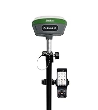
We purchased this to be used in place of, or in supplement to, a total station for survey and mapping on an archaeological project. We had been hearing from colleagues for a few years now on the merits of a dGPS in an archaeological setting and this year we felt it was time to jump on the bandwagon. This product did not disappoint. First, I will admit that what drew our attention first and foremost is the price. The fact that we could purchase not one, but two units (one to serve as a base and the other as a rover) for less than $3K, which is what we would be paying for one decent used total station, was mind-blowing. Reading the reviews gave us pretty good confidence in the product, so we pulled the trigger. The reason why we're writing this review is, however, not because of how little it cost, but how well it performed in the field. It took literally minutes to figure out the settings, thanks to little details like voice notification from the units themselves, clarity of the UI of their software (SMA Survey), and some helpful videos on YouTube. As with any new ecosystem, it takes a while to figure out what's going on (it took a little while for us to work out how stakeouts work), but once there, everything became a breeze. We were collecting topo data at the speed of walking, literally. Tilt compensation is a game changer for mapping. We even tried laying out units (which we traditionally have used the total station for), which may not be quite as accurate as a TS but the time-savings may very well offset it. What perhaps may be of most value, however, is their support. Since we were slightly anxious about taking into the field not only a newly purchased product, but a new-to-us set of instruments, I contacted their support and they immediately set up a WhatsApp support thread with us so that we could make inquiries and usually get responses within 24 hours. Their dedication to making their products easy to use in device design, UI design, and support structure is, perhaps, the real winner here. Can definitely recommend.
G**W
Reasonably Priced Equipment
Is very straightforward to use and customer support is available
A**O
El mejor calidad precio
Muy buen equipo GNSS, cuenta con muy buena precisión, compactos, graban rinex, son completos y lo que me gustó más fue su colectora, la medición de inclinación y su forma de replantear con camara con la colectora.
C**A
El mejor GPS
Excelente equipo de topografía, el software me encanta mucho. Lo mejor que he usado en GPS
Trustpilot
1 month ago
3 weeks ago