🧭 Own the Outdoors with Garmin GPSMAP 64sx – Your Ultimate Navigation Sidekick
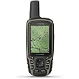
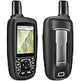
The Garmin GPSMAP 64sx is a rugged handheld GPS device featuring multi-GNSS support (GPS, GLONASS, Galileo), a 3-axis compass, barometric altimeter, and preloaded TopoActive maps for the US and Australia. Its 2.6-inch sunlight-readable color display and durable water-resistant design make it perfect for hiking, cycling, and outdoor adventures. With Bluetooth and ANT+ connectivity plus up to 16 hours of battery life, it’s engineered to keep you confidently on track all day long.


| Item Weight | 8 ounces |
| Item Dimensions L x W x H | 2.4"L x 1.4"W x 6.3"H |
| Memory Storage Capacity | 8 GB |
| Display Type | Color TFT |
| Human-Interface Input | Buttons |
| Compatible Devices | Smartphone, Tablet |
| Control Method | Touch, Voice |
| Are Batteries Included | No |
| Connectivity Protocol | Bluetooth |
| Sport Type | Hunting, Camping & Hiking |
| Battery Average Life | 16 Hours |
| Mount Type | Handheld |
| Resolution | 160 x 240 |
| Screen Size | 2.6 Inches |
| Additional Features | GPS, GLONASS and Galileo Satellites; US and Australia 100K Topo Maps; Altimeter and Compass |
| Connectivity Technology | Bluetooth |
| Map Types | Topographical |
C**.
Works well
Good product. Battery lasts long. Screen could be a bit bigger.
M**R
WOW what an upgrade
Go this after my legend CX died from batteries leaking. unit was over 10 years old. The 64 is awesome and doesnt feel like a toy at all. very powerful with built in maps. routing works, uploading maps and tacks from all trails is super super easy. edit... still works very well, after many 5+ mile treks. I did end up getting a GPSMAP65S and it is hands down the one you want. if you cant pony up 400 for the 65S, then get this one. ABC sensors are a must
D**E
PC software is confusing.
The unit itself works well. the PC software is confusing and takes time to learn how to juggle data between the PC and the handheld.
N**O
Nice straight forward GPS
This garmin GPS worked nice for my Arizona hiking trip around the Grand Canyon and other areas in Arizona. I also used while exploring the Arizona desert mountains in a Polaris RZR side by side. It actually showed the various main off road trails, I was surprised! It came preloaded with Arizona topo map. The Map had all the Arizona trails on it that I needed. Prior to leaving the trail head I would mark it as a way point after clearing the prior way point. Be sure to clear your prior foot tracks from the prior hike before starting a new trail. It kept track of my route so I could find my way back to the car. Battery life with alkaline batteries was around 14-16 hrs , I left it on continuously to test it prior to traveling. I had it only set to GPS satellite mode to maximize battery life. screen brightness was at 50%. Be sure you select the type of batteries you are using under the system settings. I then tried using Energizer lithium batteries and they lasted even longer :) . The user interface is rather straight forward after using it for a few days around my home area. I did watch a few videos to make sure I knew how to use it properly. I am not sure why people give this device poor reviews. The buttons are nice compared to a touch screen. The screen is very easy to see in direct sun light on medium brightness setting. Be sure to bring a traditional compass and general map. Be sure to familiarize yourself with the area you will be exploring
A**E
An improvement above the old.
This garmin gpsmap is so easy to set up and use. The screen may be small to some, but you can enlarge street names etc. Even topo maps can be enlarged. Like the fact that you can choose what type of battery installed. I'm using straight up alkaline batteries.
L**Y
Love the Topactive map
I have used several Garmin handheld unit in the past 20 years with both 100K and 24K maps. I use my GPS for biking and hiking with a little geocaching now and then. I have been very happy that all the trails that I’ve gone on this year have been on the map which my 600T did not. Plus the topoactive maps receive updates so you have updated information all the time. So far it’s the best that 8 have used. Happy Trails.
J**5
The blunt truth
I knew I wanted this and would like it, I didn't think it was advanced as it is! Very much worth every penny! What's failed to be mention is you do need the 30 dollar a year subscription if you want 3d terrain. Even that wasn't an issue and love the user interface on gps and the Birdseye subscription! 5 stars for me all day! And I'm a very picky tech savvy guy lol
T**S
awesome, use it much! a lot in the woods.
reason why i got it, i go many places where there is no celphone service. so can't use the maps on my phone. i use it a lot! it keeps track of all my trails i have been on. i down load all info onto my mac computer.
Trustpilot
1 maand geleden
2 weken geleden